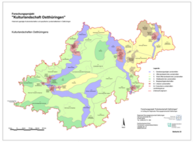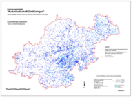
Cultural landscape of East Thuringia
Cultural landscapes are visually becoming increasingly interchangeable: One commercial area looks (almost) like the other, one single-family home settlement is often the same as the other, the Black Forest house is now also being built in Mecklenburg-Western Pomerania. The effect of uniformity can be experienced in a similar way in the open landscape. All in all, a gradual leveling process is taking place that gradually fades and disappears regional types, peculiarities and specifics. With this regional “coloring”, however, also disappears what makes one region distinguishable from others and recognizable. This trend can also be observed in East Thuringia.
Which landscapes in East Thuringia are still typical and distinctive today? What defines the regional typology of the various regions of East Thuringia, what exactly is the reason for their unique landscape - their "own kind"? And how should this be further developed in the future? The research project, which was commissioned by the Regional Planning Association of East Thuringia, was devoted to these and related questions in order to find ways for the updating of the regional plan to preserve and further profile the regional typology and landscape characteristics.
The key to counteracting the unification and interchangeability of space and landscape is ultimately to perceive the landscape more strongly in its historical roots and to understand it as a continuum of time, coming from the past and going into the future. This has nothing to do with “homeland fuss” and a feared conservation of the landscape. On the contrary: The inclusion of the past in the observation group makes it possible to rediscover “forgotten” and “overlooked” elements of a landscape and to make its “history” legible and tangible
Results


The research project 'Historically shaped cultural landscapes and specific landscape images in East Thuringia' ended on December 31, 2004. The resulting research report is presented online here. This consists of a text part with 7 chapters and an extensive appendix, as well as a map part with a total of 10 DIN-A0 (not published) and 24 DIN-A3 cards.
![]() Cultural landscape project of East Thuringia (link opens extern project website)
Cultural landscape project of East Thuringia (link opens extern project website)